The conquest of Dahomey (1890-1894)
On 27 October 2021, France, in accordance with a promise made in 2017 by the President of the Republic, returned to Benin 26 objects taken during the conquest of the Kingdom of Dahomey between 1890 and 1894.
These 26 objects - royal objects or regalia that belonged to the kings of Dahomey - had been entrusted to the Musée de l'Homme, installed at the Trocadero, in 1894 by General Dodds, commander of the two expeditions of 1892 and 1894, after the defeat of King Behanzin and the establishment of the French protectorate. They were kept and exhibited at the Quai Branly - Jacques Chirac - Museum of Primitive Arts.
This historical event gave rise to a scientific event during which the SHD was invited to present its archives concerning the expeditions to Dahomey, and to evoke the stages of this military conquest.
The kingdom of Dahomey was an old African kingdom, born in the 17th century, which had established relations with France in the context of the slave trade. At the end of the 19th century, King Behanzin, who came to the throne in 1889, intended to resist French interference militarily and to challenge the agreements that had been made. It was in this context that France undertook the colonisation of Dahomey.
This conquest was organised in three stages, punctuated by three military-scientific expeditions. The first expedition, which aimed essentially to defend the French trading posts on the coast, was entrusted to Commander Terrillon of the Troupes de Marine and took place from March to April 1890. It ended with the battle of Atchoupa, on 20 April 1890, and a French victory. A first peace treaty was signed on 3 October 1890, but it was not ratified by the Chamber of Deputies. The situation between the kingdom of Dahomey and France remained tense, with King Behanzin, hostile to French interference, opting for a policy of force and confrontation. A second expedition was organised from July to December 1892, preceded by a maritime blockade of the coast. This time it was no longer a question of defending the French establishments with a rapidly built-up force, but of leading an expedition into the heart of the kingdom of Dahomey, with the eventual establishment of a protectorate. The expedition was entrusted to Colonel Dodds. Starting from Cotonou and Porto Novo, the French column went up to Abomey, the capital of the kingdom of Dahomey, occupied on 17 November 1892. It was there that the now General Dodds had the royal objects seized and sent to France. He also proclaimed the deposition of King Behanzin, but did not manage to take him prisoner. This was the aim of the third expedition, from October 1894 to January 1895. It ended on 15 January with the proclamation of a new king of Dahomey, allied with France, then with the surrender of Behanzin, and finally with the proclamation of the French protectorate over Dahomey on 29 January 1895.
With Behanzin defeated, Upper Dahomey opened up to French penetration, with the Niger in its sights. According to the Minister of Foreign Affairs, Delcassé, the aim was to keep the road to the Sudan and Niger open by establishing a French sphere of influence in Upper Dahomey. From 1894 to 1898, a series of missions made it possible to establish this French trusteeship, recognised by a series of conventions with Germany and the United Kingdom between 1897 and 1898.
Our advice: to enlarge the image, click on the magnifying glass and then right click to open the image in a new tab. And there you can zoom in!
The progress of colonisation through maps (1889-1893)La progression de la colonisation à travers les cartes (1889-1893)
These four maps held by the SHD were drawn up between 1889 and 1893. Their comparison reveals the progression of the exploration of the land by the French (civilians and then soldiers), first along the coast and the waterways, then on the routes of military conquest. The illustrations and certain place names reflect the imagination and prejudices used to justify colonisation. The precision of the surveys and the geographical layout also recall the expertise of the officers and the dedicated services in the field of topography.


Map of French settlements in the Gulf of Benin, Victor Ballot, 1889.
This map was drawn up by the administrator of the French establishments, or resident, in Benin, Victor Ballot, in 1889. At that date, only the coast and the localities along the rivers are known, and therefore represented, punctuated with tricolour flags indicating the French trading posts. The routes of the main exploration missions from Whidah (or Ouidah) to Abomey, between 1845 and 1871, are indicated by a straight line. The rest of the map shows the 'unexplored regions' in white.
Map of Dahomey and neighbouring countries, J. Hansen (geographer), 1892
This map 'drawn up according to the most recent explorations', i.e. after the first two military expeditions of 1890-1892, presents the most recent knowledge concerning the topography, toponymy, climate and landscapes of the territories of Dahomey. The southern part of the territory is already called "French territory". It lies between the neighbouring territories conquered by the Germans and the English.
The illustrated vignettes, the place names, and the notes on the climate, the population, the economy, the population, are a mixture of rigorous scientific observations and epinal images, even prejudices justifying the expeditions in the name of a "civilising mission" of France: The coast is still called the "slave coast"; the north-eastern territories are referred to as "kingdoms ravaged by the warmongering Dahomey"; weapons used for human "sacrifices" and skulls displayed on the ramparts of Abomey are presented; "superstitions" and the "cult of fetishes" are illustrated by a "snake temple"; the ferocious and famous Amazons of Dahomey are also represented.


Map of Dahomey drawn up by order of General Dodds, based on the work of the officers of the expeditionary corps, 15 March 1893.
This map was drawn up by the military (the topographical office of the headquarters of the troops in Benin), using, the notice states, the reconnaissance work of the officers of the expeditionary force, and information obtained during interrogations conducted by the 'service des affaires politiques de la colonie du Dahomey'. It can be seen that knowledge of the territories to the north has progressed considerably, not only around Abomey, the capital conquered in November 1792, but well beyond. The territories to the south are now called 'annexed territory'. Knowledge of the whole, however, is still limited to the routes used.
Map of Dahomey drawn up according to the information of Commandant Trinité-Schillemans, 1 July 1893.
Although it was drawn up shortly after the previous one, by the same services (Commandant Trinité-Schillemans was the head of the political affairs service already mentioned), this map is even more complete. This precise description of the territory illustrates the deepening of French domination over the now named colony of Dahomey. The various borders - the limits of the annexed territories, of the kingdom of Porto-Novo, of the provinces of Allada and Abomey - were this time clearly traced. Exploration was no longer limited to the vicinity of the roads. Only the territories further north remain dotted.

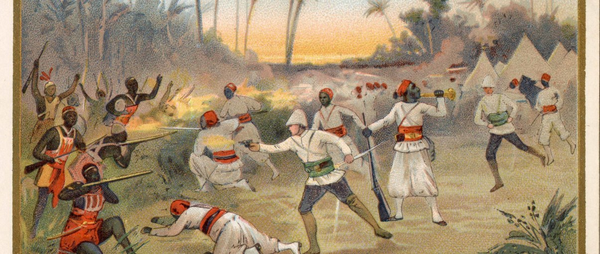
The second Dahomey expedition in Epinal pictures.
Postcards illustrating the Dahomey campaign, undated.
These postcards with gold edging, which were found in chocolate bars, indicate that the campaign took place in 1892 but illustrate events in 1893. Magnifying the French colonial gesture, they depict the major French victories in Dahomey, the ever-victorious French repelling brave and exotic enemies, not least the Amazons of King Behanzin. The uniforms, weapons and landscapes are barely sketched, but all the elements are there to anchor the legend in the mind.

The attack on the Dogba camp by the Dahomeans (19 September 1892).
The Fons warriors and the Amazons of King Behanzin in their colourful outfits attack the French camp in the early hours of the morning: a skirmisher sounds the alarm, while skirmishers and legionnaires dressed in white rush in against a backdrop of tents and the rising sun. The French won after a fierce battle, during which Major Faurax was killed.
The capture of Qana (4 November 1892).
The picture shows the last bayonet charge of the legionnaires and riflemen against the soldiers and Amazons of Behanzin, before taking the royal palace in this 'holy' city of Dahomey.


Entry of the flag into Abomey (17 November 1892).
In good order, the French troops (marine troops and riflemen) enter the Dahomean capital, abandoned by King Behanzin, with the tricolour flag. It was the end of the second expedition. The population welcomes the French as liberators, presenting them with their children; as a reminder of the "barbarity" justifying the conquest, the skulls of the "sacrificed" still adorn the ramparts, and the city, which would have been set on fire by the king at the approach of the enemy, like Moscow facing Napoleon, burns in the background.
The exile of King Behanzin in photographs.
King Behanzin finally surrendered in January 1894 and was deported to Martinique with his family. This exile was immortalized by a few black and white photographs taken by a sailor on the schooner "La Mésange".
Behanzin and his family
The exiled king remains dignified; he is surrounded by his relatives - women and a child. One of the women holds an umbrella to protect his head and another seems to be bringing him a drink. The looks are serious, but not overpowering. In the background are French soldiers wearing colonial helmets; on the left, ropes remind us that we are on a ship.


Behanzin's ministers
Proud and resigned, the ministers of Behanzin pose on the deck of the Mésange. As a reminder of the victory, the motto 'Honneur et patrie' (the motto of the French army) is displayed above their heads. One of their jailers, a sailor armed with a rifle, poses with them, but curiously blurred by the light, he seems to fade away in front of the dignity of this government in exile.
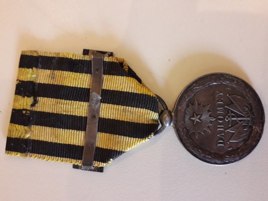
Memory of the expedition
Dahomey Expedition Commemorative Medal, Symbol Division, 1892.
This medal was created in 1892 and first presented to General Dodds on his return to France. The obverse shows the helmeted effigy of the Republic framed by a laurel wreath; on the reverse, a star symbolising France's influence on the world, a trophy of four flags recalling the victory, and a naval anchor for the naval troops. Its ribbon, daffodil yellow cut with black stripes, is the same as that of the Tonkin expedition commemorative medal (1883-1885).